Official Town Plats Confirm the Exact 1,366.87-Foot Shared Boundary & 25-Foot Buffer
Source Documents: PC 2022-04 Primary Plat (Stoeppelwerth & Associates, Inc.), PC-24-14 Winterfield Section 3 Secondary Plat (Recorded July 2024), and PC 2022-04 Plan Commission Staff Report.
Fact-Checked Survey Measurements Along Winterfield's Western Boundary
- • Official Plat Callout (Sheets C100 & C107): "Now or Formerly Raymond Eugene & Terry Lee Canary | Instr. No. 2007-012267 | Zoning: IL"
- • State Parcel ID:
41-08-02-041-019.000-012(92.58 Acres at 2385 N. Graham Rd). - • Directly Abuts: Winterfield Lots 246–262 (numbered Lots 247–262 on the 2022 Primary Plat; renumbered Lots 246–262 on the 2024 Section 3 Secondary Plat) and Common Area #13 (Lake #4).
- • Mandatory Buffer Yard: Because the Canary tract is zoned IL (Industrial: Light), the plat establishes only a 25-foot Buffer Yard Type 3 (
25' TYPE 3 BUFFER) behind those homes.
- • Official Plat Callout (Sheet C107): "Now or Formerly Shawn Alberty & Charlona Ann Sullivan | Instr. No. 2007-012267 | Zoning: Agri"
- • Directly Abuts: Winterfield Lots 242–245 and Wetland Common Area #12 in the northwest corner of Winterfield.
- • Buffer Requirement: Requires only a 10-foot Buffer Yard Type 1 because that northern neighbor is zoned Agriculture (
Agri). - • Total Combined Western Boundary:
1,366.87 ft + 703.51 ft = 2,070.38 linear feet. Total Winterfield size: 130.63 acres (320 single-family lots).
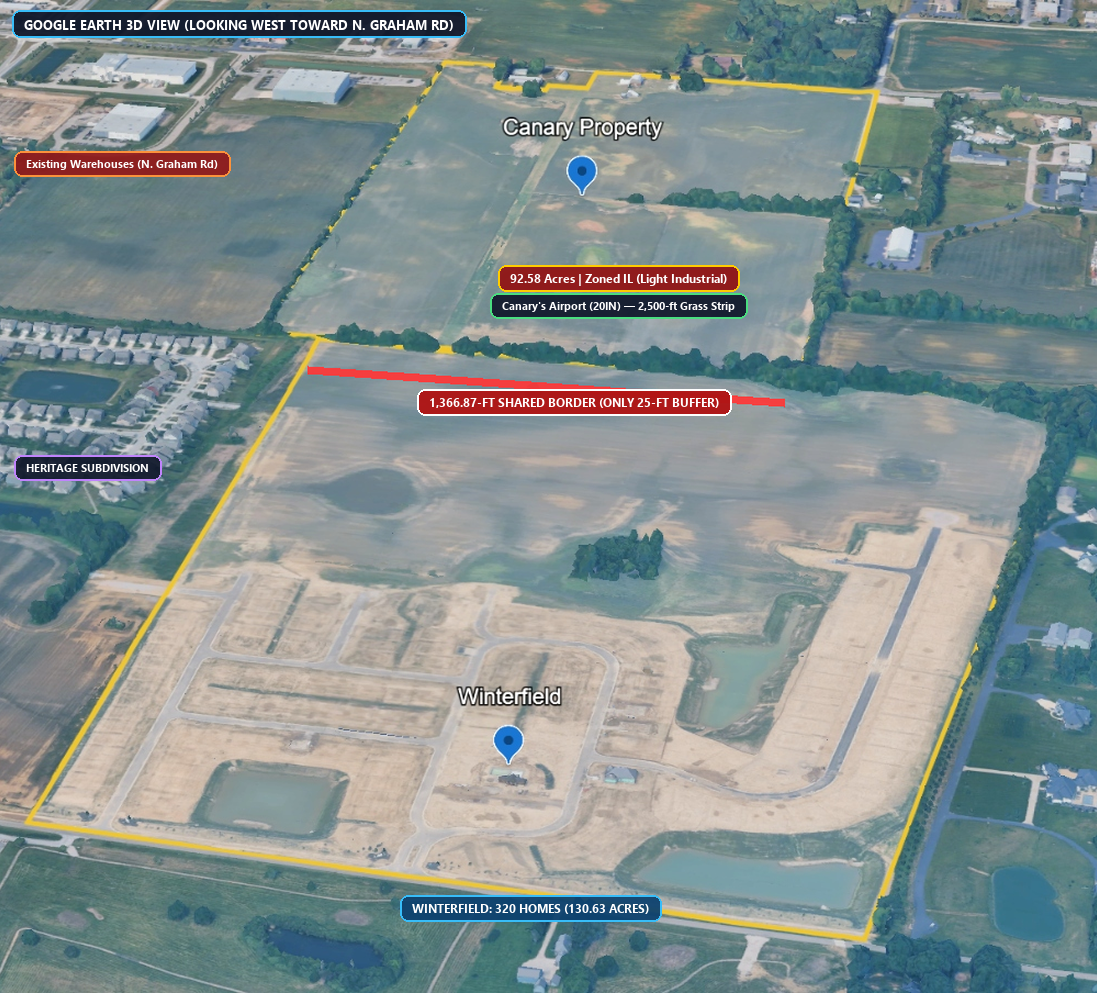
Confirms the yellow parcel outline in Google Earth matches the 1,366.87-ft tree-line border and homestead cutout on N. Graham Rd.
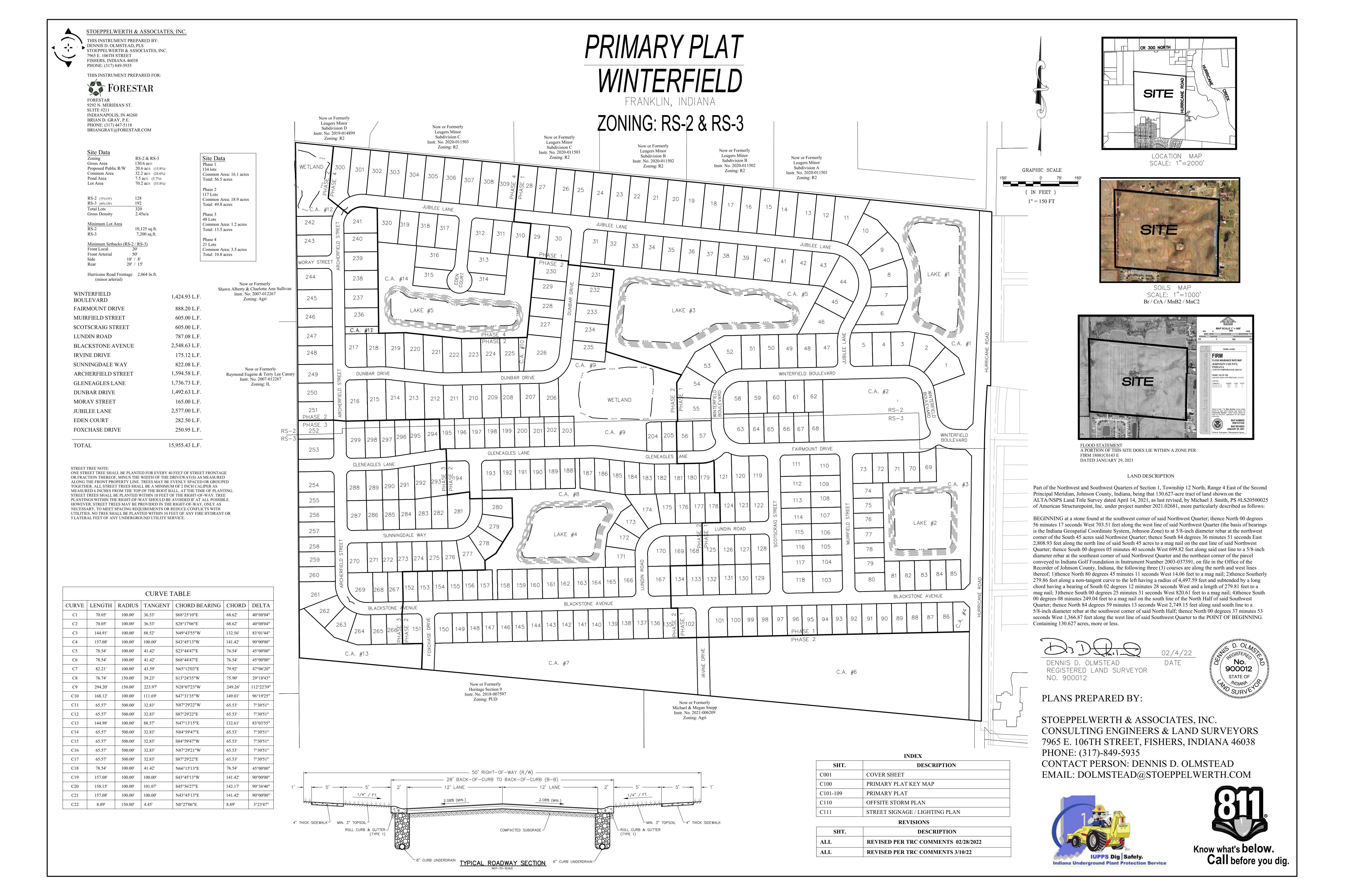
Shows all 320 Winterfield lots (130.63 acres) and the explicit "Raymond Eugene & Terry Lee Canary — Zoning: IL" callout on the west border.
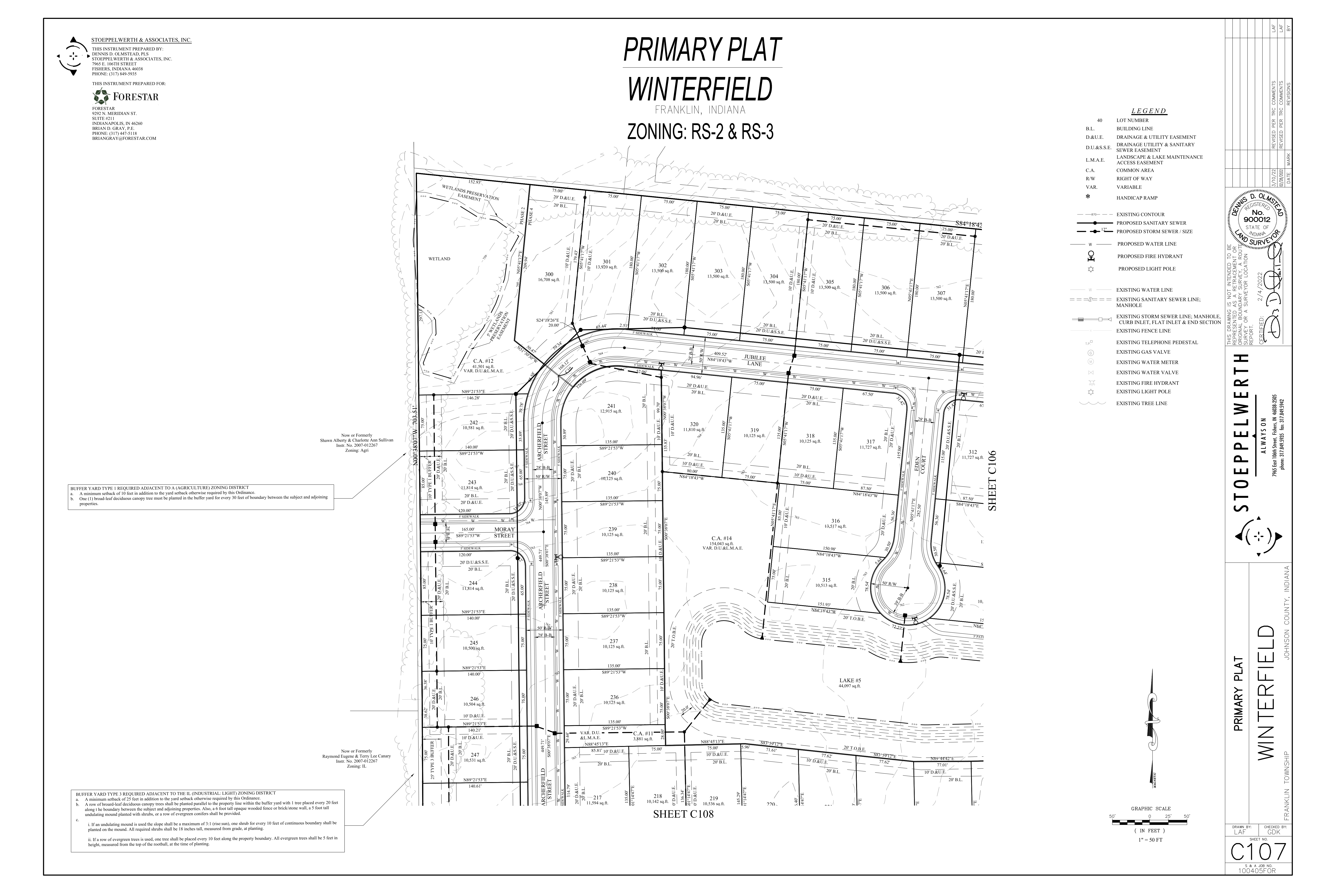
Engineering sheet detailing the transition from the 10-ft Type 1 buffer (north) to the 25-ft Type 3 industrial buffer behind Lots 246–262.
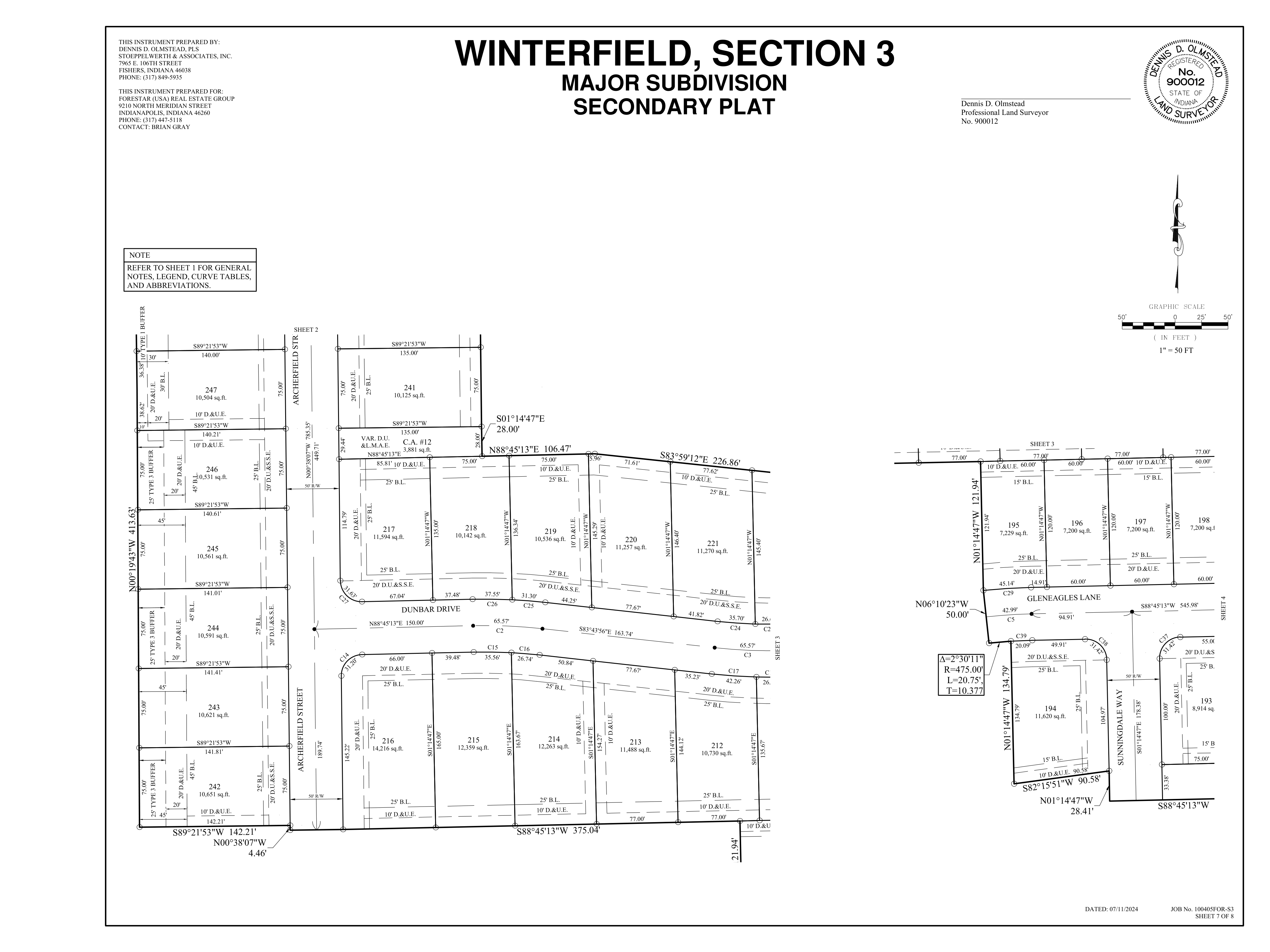
Final stamped plat (dated 07/11/2024) showing the exact recorded boundary bearings and 25-foot Landscape Buffer Easement along Lots 246–253.
Why Paving the Canary Tract Causes Backyard Flooding: The City's Own Runoff & Wetland Reports
Source Documents: PC 2022-04 Drainage Report (Stoeppelwerth & Associates, Inc.) and PC 2022-04 Wetlands Delineation Report (Earth Source, Inc., Feb 24, 2022).
24.44 Acres of Winterfield Drain West Into the Canary Tract
According to the official Drainage Basin Map (Exhibit EX-1) in the PC 2022-04 Drainage Report, Winterfield sits on a watershed divide. While eastern Winterfield drains east to Hurricane Creek, Basin J (19.64 acres) and Basin F (4.80 acres) along the western border drain westward across the Canary property into the Canary Creek / Canary Ditch watershed.
Wetlands D & F + Federal WOTUS Creek Channel
Earth Source's field delineation documented Wetland D (0.52 acres, emergent wetland), Wetland F (0.34 acres, forested wetland), and a defined Waters of the U.S. (WOTUS) stream channel (Photos 11–14) flowing northwest out of Winterfield directly onto the Canary parcel toward Canary Ditch.
Brookston Hydric Clay Soils & Impervious Surge (CN 98)
The border is underlain by poorly drained Brookston silty clay loam (Br) with a 0–1 ft seasonal water table already prone to surface ponding (Site Photo 12). Paving 92.58 acres of farmland (Curve Number ~76) into impervious concrete warehouse roofs and truck courts (Curve Number 98) eliminates natural soil percolation and backs floodwater into adjacent yards.
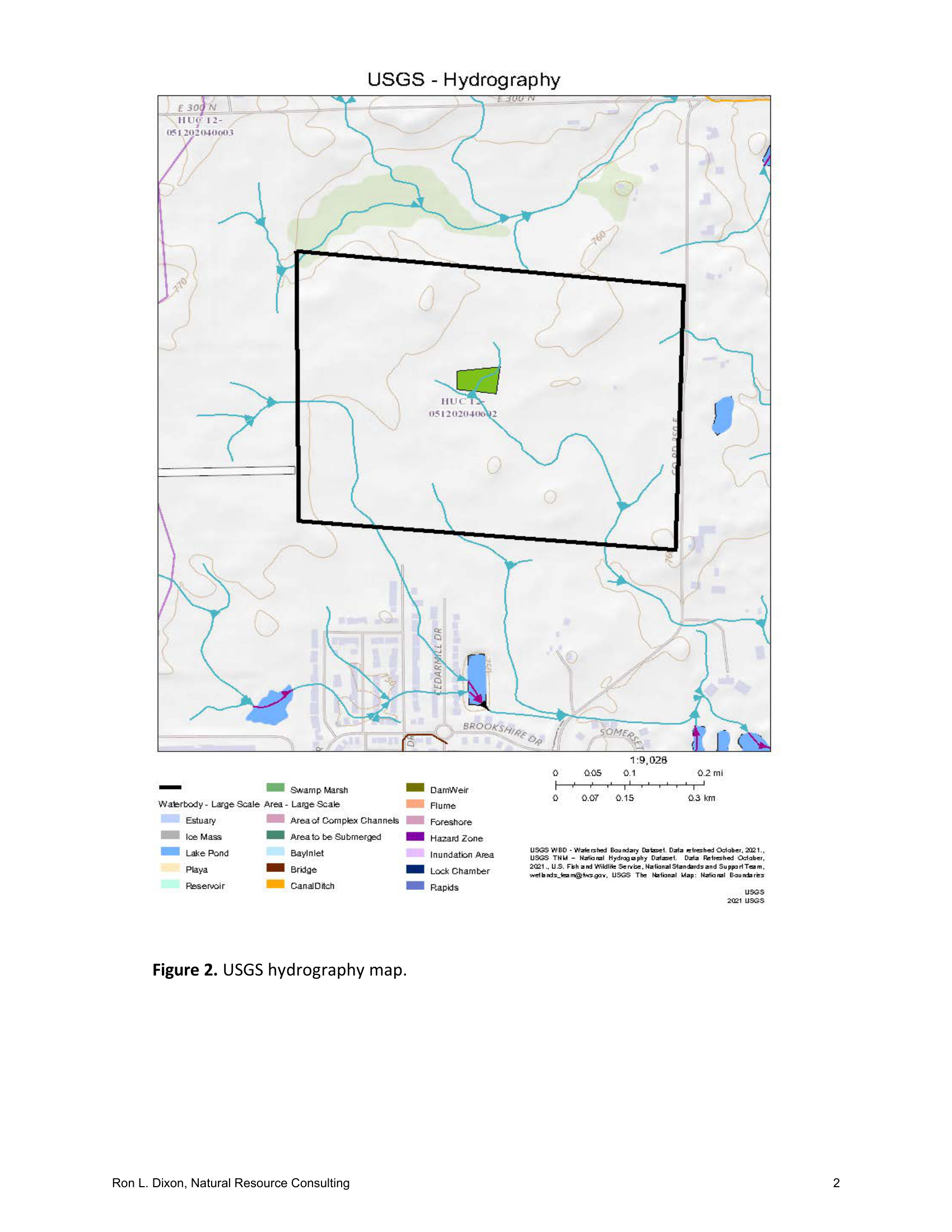
Official USGS topographic map from the Wetlands Report showing blue stream flow arrows running west/northwest across the Canary parcel.
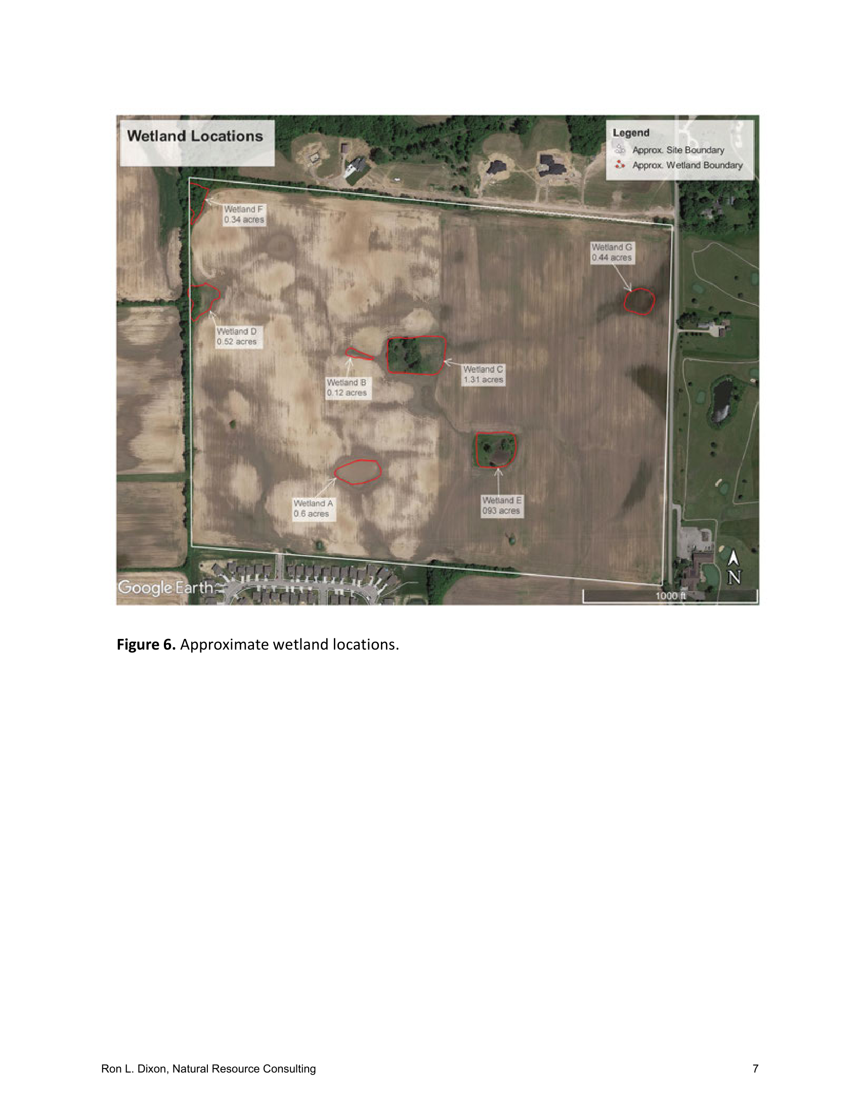
Shows delineated Wetlands D & F and the federal WOTUS stream channel right along the western boundary shared with the Canary property.
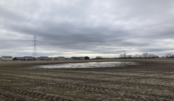
Field photograph from the 2022 Wetlands Report showing seasonal surface water ponding on poorly drained Brookston clay soil next to homes.
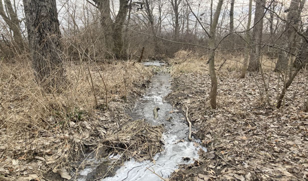
Field photograph showing the natural wooded creek channel carrying western Winterfield runoff into the Canary Creek basin.
How a Park vs. Industrial Warehouses Directly Impacts Your Home Value
Based on peer-reviewed hedonic property valuation research from the National Recreation and Park Association (NRPA), the National Association of Realtors (NAR), and commercial/industrial adjacency appraisal studies.
+$17,500 to +$70,000 Value Boost on a $350,000 Home
Known in real estate economics as the "Proximate Principle" (verified across 30+ empirical studies by Texas A&M, NRPA, and NAR), single-family homes within 500 to 1,500 feet of a community park, playground, walking trail, and protected woodland buffer consistently sell faster and command a 5% to 20% price premium.
-$52,500 to -$87,500 Equity Loss on a $350,000 Home
Appraisal studies of residential subdivisions bordering heavy truck distribution centers document immediate 15% to 25% market value discounts for perimeter and nearby homes—along with buyer seller-disclosure obligations regarding adjacent industrial noise, light, and drainage issues.
How the City Can Force or Fund the Park on the Buffer Portion—With Money Left Over for the Playground & Restrooms
In Johnson County's 2025–2026 land market, buying all 92.58 acres outright at developer prices ($3M–$5M+) would consume the entire $1.5M+ Park Impact Fee fund and leave nothing to build the playground. Instead, the City has three powerful mechanisms to secure a 15-to-25-acre park and buffer on the eastern portion while keeping $650,000 to $1,100,000+ available to build the playground, restrooms, and parking lot right now:
If D.R. Horton (or Any Builder) Wants the Land: Force a 15–25 Acre Park Dedication ($0 Land Cost)
Because 2385 N. Graham Rd is currently zoned IL (Light Industrial), D.R. Horton or any residential builder CANNOT build homes there without a Rezoning vote from the Franklin Plan Commission and Common Council. That gives the City 100% legal leverage to require the developer to dedicate the eastern 15–25 acres (covering the 1,366.87-ft border and Canary Creek wetlands) to the City for $0—leaving 100% of the $1.5M+ Park Impact Fee fund to build the playground, restrooms, and parking lot (plus collecting another $2,490/home on every new home built!).
Buy Only the 15–25 Acre Eastern Buffer & Wetland Corridor (~$450k–$750k)
Most Franklin city parks are 10 to 25 acres. Furthermore, the eastern/central portion of the Canary tract contains Wetlands D & F, the federal WOTUS stream, and poorly drained Brookston hydric clay soils that are expensive or unbuildable for warehouses anyway. Acquiring 15 to 25 acres along the Winterfield/Heritage border for ~$450k–$750k leaves $750,000 to $1,050,000 inside the Park Impact Fee account to immediately construct the airplane playground, restrooms, shelter, and parking lot.
Enforce Canary Ditch Flood Storage + Double the Fund to $3.0M With State Grants
Any industrial developer must pass the Franklin Technical Review Committee & Johnson County Drainage Board, which can mandate massive eastern stormwater detention and wetland preservation for the 24.44 acres draining from Winterfield. Simultaneously, using the City's $1.5M impact fee balance as a 50/50 local match for an Indiana DNR Land & Water Conservation Fund (LWCF) or Next Level Trails grant doubles the City's budget to $3.0 Million+.
Itemized Municipal Construction Estimate: Canary Airfield Park
2026 Central Indiana municipal construction rates on flat ground (minimal grading required)
| Park Facility / Item | Scope & Engineering Specification | Modest Build | Full-Featured |
|---|---|---|---|
| 1. Memorial Plaque & Limestone Boulder | Cast bronze plaque (24"×36") honoring Gene & Terry Canary on an Indiana limestone boulder | $4,000 | $8,000 |
| 2. Airplane-Themed Playground | Commercial municipal airplane play structure, swings, toddler zone, curbing & safety surfacing | $150,000 | $275,000 |
| 3. Public Restrooms & Picnic Shelter | Durable brick/concrete 2-stall ADA municipal restroom building + covered picnic pavilion | $140,000 | $240,000 |
| 4. Water, Sanitary Sewer & Electric | Utility laterals connected to adjacent Winterfield municipal water/sewer mains | $50,000 | $95,000 |
| 5. Paved Parking Lot (25–40 Spaces) | Compacted stone base, asphalt paving (~12,000 sq. ft.), ADA stalls, striping & entrance apron | $85,000 | $145,000 |
| 6. Paved Walking & Biking Trail Loop | 8-to-10-foot wide asphalt multi-use loop trail (~0.75 to 1.1 miles on flat grade) | $150,000 | $225,000 |
| 7. Stormwater Basin & Hardwood Buffer | Shaping retention pond along Canary Creek + 100–150 native shade trees & meadow seeding | $70,000 | $125,000 |
| TOTAL ESTIMATED TURNKEY PARK CONSTRUCTION COST | $649,000 | $1,113,000 | |
Verified Historical Record: Gene Canary (1928–2024), Terry Canary (1950–2026) & Canary's Airport (FAA: 20IN)
Raymond Eugene "Gene" Canary (Dec 18, 1928 – Feb 24, 2024, Age 95)
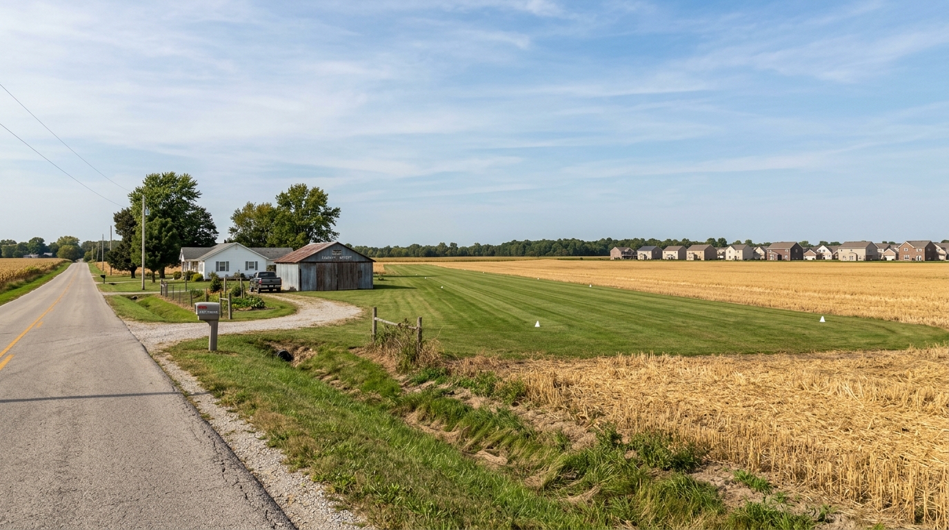
Born in Franklin to Orien Bass Canary and Neva Elaine (Drayer) Canary, Gene graduated from Alva Neal High School in 1947. He farmed the family homestead at 2385 N. Graham Rd and painted/repaired farm equipment (initially at Deer & Son International Harvester). A passionate aviator, he built his own open-cockpit biplane and maintained a 2,500-ft by 60-ft private grass landing strip (Canary's Airport, FAA Identifier: 20IN, Runway 9/27). His official Swartz Family Community Mortuary obituary also highlights his famous lifelong dedication to restoring historic U.S. military artifacts and ammunition and personally delivering/donating them to U.S. military bases, including Grissom Air Force Base and Dover Air Force Base.
Terry Lee Canary (July 12, 1950 – Aug 15, 2026, Age 76)
Son of Gene and Betty R. (Wagoner) Canary, Terry graduated from Franklin Community High School in 1968. Terry was a United States Air Force Veteran, serving from 1971 until his honorable discharge in 1974, and worked professionally as an electronics technician. For several years, he also served at Camp Atterbury and Muscatatuck Urban Training Center as a COB (Citizen on the Battlefield), roleplaying in live training exercises to prepare deploying U.S. military troops—where he earned recognition as the "#1 COB". Following Terry's passing on August 15, 2026, the 92.58-acre property entered estate transition.
Download Official City of Franklin Engineering & Survey PDFs
Click any file below to open or download the original, unaltered municipal PDFs directly from our repository:
Stoeppelwerth ALTA Survey & Primary Plat showing the 1,366.87-ft Canary IL border & 25-ft buffer (4.1 MB).
Recorded July 2024 Section 3 Plat detailing western Lots 242–253 and the 25-ft buffer easement (1.1 MB).
Official Franklin Plan Commission Staff Report confirming 130.63 acres, 320 lots, and Type 3 Buffer (304 KB).
Stoeppelwerth stormwater calculations & Basin Map proving 24.44 acres (Basins J & F) drain west (8.2 MB).
Earth Source delineation of Wetlands D & F, WOTUS stream channel, USGS maps & site photos (4.0 MB).
Printable petition text and comprehensive property dossier for City Hall and Park Board meetings.
Ready to Help Protect Our Neighborhood?
Now that you've reviewed the official plats, drainage studies, and financial numbers, add your name to the neighborhood petition and send a 1-click email to Franklin decision-makers.